May 2020, Vol. 247, No. 5
Features
Wider Horizon Coming for Drone Monitoring
By Nicholas Newman, Contributing Editor
Oil and gas pipeline safety and smooth operations are crucial. Therefore, regulations require frequent inspections and continual monitoring to detect potential threats ranging from third-party damage, corrosion, fires, flooding, landslides and slips.
Accordingly, deploying teams of people on the ground and helicopters in the air to cover the length of the pipeline network is a major cost for North America’s pipeline industry.
To put that in perspective, the United States has an estimated 518,315 miles (834,150 km) of transmission pipelines to police. Inspection and monitoring represent a major expenditure in the 50-year lifetime of pipeline reports. The use of drones can reduce traditional surveillance costs by nearly 90% and head off property damage, according to some analysts.
Recent advances in computing, software and sensor technology allow drones to be programmed to operate automatically on a predetermined flight path. This opens the way for automating inspection and monitoring pipes with aerial drones transmitting high-resolution, high-accuracy data.
Current aviation, health and safety regulations restrict drones to flying within the line-of-sight of their operator. However, this is about to change. The unmanned aerial vehicles (UAV) industry is growing at breakneck speed. Consequently, there is pressure to liberalize these restrictions.
Benefits
Pipeline operators will be major beneficiaries of the forthcoming liberalization, which will allow drones to fly much closer to pipeline infrastructure than ever before and collect data that are both quantitatively and qualitatively superior for pipeline managers.
Customized drones will transform pipeline inspections, providing real-time leak detection and monitoring of the 2.4 million miles of energy pipelines of North America and save costs. For example, Xcel Energy in Colorado calculates that flying drones will cost between $200 and $300 per mile.
Fortunately, pipeline operators can now hire drones from third parties.
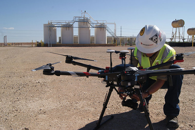
“Drone companies like Precision Hawk do more than provide the drone technology to customers, they provide the training to operate the drones, the software to manage and automate flights and the cloud computing analytics to process the date collected,” said Vice President Patrick Lohman of drone services provider Precision Hawk.
There were an estimated 450,000 commercially registered drones in the United States in 2019, according to the Federal Aviation Administration (FAA), and the market was worth over $4 billion, according to the Financial Times.
Consultants at McKinsey & Company expect the UAV industry to grow to $26 billion by 2026, with the oil and gas industry providing a major market segment.
Drones and Pipelines
Pipeline operators use drones in a range of tasks beyond monitoring and inspection. Drones are useful for surveying planned routes, providing digital elevation maps and dedicated sensors for methane management, as well as supporting emergency response and perhaps delivery of materials.
Drones are proving invaluable for remote monitoring and surveillance of pipeline infrastructure, related equipment, vehicles and other assets. The high-resolution color imagery and 360-degree views of assets and encroachment detection at a relatively low cost have transformed both the economics and the efficiency of pipeline monitoring. In an age of climate anxiety, drones also are more environmentally friendly than transporting inspection teams by road or helicopter.
Today’s drones are flying platforms, equipped with a variety of sensors, thermal imagers and cameras. For example, light detection and ranging sensors allow close-range views of assets to detect potential flaws, such as cracks and leaks, and give quick access to data. This, as Lohman said, “cuts time on the job and improves efficiency in assessing pipelines and other related infrastructure, such as pumping stations.”
By merging drone data with advanced data analytics and cloud-computing, it is now possible to assess the state of equipment, enabling managers to make predictive maintenance decisions. Or, as Lohman states, “enable operators to be more proactive in the inspection of all assets in real time.”
Technology and delivery companies are currently experimenting with delivery of packages and material to customers by drone. This has gained the attention of pipeline construction companies whose managers are looking at the possibilities of delivering pipeline sections to remote, difficult or mountainous terrain.
Methane Management
Methane emissions are now the focus of climate policies. In response, pipeline operators are using drones with a payload of sensing technologies to detect methane leaks in real time.
Norway’s Equinor is developing technology that uses laser-based sensors for detecting methane leaks. ABB’s Ability 3-kg (7-pound) mobile gas-leak detection system can now be fitted on a drone and flown over natural gas pipelines to detect gas levels at parts-per-billion granularity.
In the event of an industrial accident or natural disaster, drones can provide an eye-in-the-sky view of the scene and ongoing developments. Their sensors collect and transmit images. Drones’ data analytics process the information to provide a picture of damage from flooding, landslips and earthquakes or sabotage, and oil and gas leaks.
This real-time, high-quality information stream allows pipeline operators to coordinate their emergency response and directs the right resources to the right locations to better provide for employee and public safety. For example, Marathon Pipe Line has used drones to accurately assess flood situations.
Restrictions
The use of drones is regulated by aviation rules and constrained by both operational issues and flight ranges.
Many countries, including the United States and the United Kingdom, regulate civilian drone activity. Currently, drones are not allowed to fly beyond the line-of-sight of a human operator and must comply with airspace operating restrictions.
In addition, there are site safety-risk assessments, equipment preparation, notifications and employee training requirements before a drone flight can take place. The United Kingdom is a case in point, with the beyond-line-of-sight specification being 0.3 miles (500 m) away from the pilot and 0.75 miles (120 m) from ground level. This would be adequate for basic visual or thermographic inspection but remains limited.
Above and beyond regulations, the specialized knowledge and training requirements of drone usage have encouraged more pipeline companies to employ specialist operators, such as Precision Hawk, Trinity Services and Consulting and Terra Drone Corporation.
Still, there is no solution to current battery technology, which limits the distance and length of time commercial drones can remain in the air. The flight time of a typical drone ranges from a few minutes to a little more than an hour.
Skyfire Consulting, in partnership with drone company Doosan Mobility Innovation and hydrogen-fuel service provider ReadyH2, is using a hydrogen-powered generator to provide two-hour flight times and a 50-mile range to assist the inspection effort of an unnamed U.S. company.
Conclusion
Even within the current flying restrictions, drones have become an important tool for oil and gas companies, pipeline owners and operators. Beyond the horizon, drones appear to have a sunny future.
Liberalization of flying restrictions and further advances in technology will ensure rapid growth in drone usage. And when flying drones beyond the horizon is fully allowed, one could comfortably predict that the sky will be the limit.

Comments