Build A Proactive Geohazard Management System Through Advanced Data Analytics
M. TORRES, ROSEN Group, Houston, Texas (U.S.); and E. BENNETT, ROSEN UK, Newcastle upon Tyne, United Kingdom
(P&GJ) — Pipeline operators have long dealt with the consequences of shifting ground, unstable slopes, heavy rainfall and other environmental pressures. These forces do not always announce themselves: when they do, the warning often comes late, after the steel has already begun to show signs of strain. Many integrity teams still rely on manual reviews, incomplete terrain information or scattered datasets that are difficult to combine. This creates blind spots, especially in remote areas where ground conditions can change faster than operators can respond.
The industry has reached a point where traditional tools can no longer keep pace with the evolving risks of geohazards. Operators are seeking a more dependable, integrated approach that brings together geoscience, integrity data and modern computing so they can discover potential issues before they reach the pipeline. The framework described here moves toward that goal, consolidating diverse data sources, organizing them consistently and providing actionable insights without overwhelming users with raw information.
Why operators need a new approach. Most existing geohazard programs fall into two categories:
- Static, map-based methods that are built on historical indicators of slope instability.
- Reactive methods that are triggered by field observations, aerial patrols or in-line inspection (ILI) results.
While both have value, neither delivers a dependable, forward-looking view of geohazard risk.
Environmental conditions rarely follow simple patterns. Slopes fail for different reasons in different landscapes, rainfall and groundwater levels fluctuate quickly, and soil behavior varies over short distances. When terrain shifts, it often does so without much notice. Because of this, operators may find themselves reacting to a problem rather than preventing one, even when they have invested effort in monitoring.
A more capable system must provide early context, including what the landscape looks like, how it behaves and how the pipeline responds when the ground moves. Without a shared structure, bringing these pieces together is difficult, and many operators have highlighted this challenge. The work described here is intended to provide them with a more reliable foundation.
A framework built around real pipeline behavior. The central idea is straightforward: geohazard risk depends on the environment and how the pipeline reacts to it. A weakened slope may pose little danger if its movement does not pose an excessive load onto the pipeline. However, the same slope could cause significant strain under slightly different conditions. Understanding this interaction requires combining geospatial information with integrity data in a way that is both consistent and scalable.
This framework gathers data from a wide range of sources, including satellite elevation models, geological and soil maps, precipitation and temperature records, land-use information and public datasets on landslides. It also incorporates ILI results, including bending strain and pipeline movement. When these datasets are viewed together rather than as isolated inputs, operators can see the broader picture instead of a collection of disconnected signals.
One major advantage of this development is a data warehouseᵃ that stores thousands of past inspections and enriched geospatial data. Rather than starting from scratch each time, the system can compare new locations to known patterns globally, helping analysts focus on segments that deserve the most attention.
Making landslide assessment more practical. Among environmental threats, landslides stand out because of their frequency and the damage they can cause. However, predicting large-area landslides can be costly and time-consuming. To provide practical support to operators, the framework uses slope units, which are terrain sections shaped by natural drainage and topography. Each section tends to behave as a distinct block during a landslide, making it a useful tool for assessing hazard potential.
Rather than treating the ground as a series of isolated points, slope units group the ground into meaningful, geologically consistent areas. This makes it easier to recognize patterns and evaluate how the pipeline intersects or parallels terrain features. The ability to compute these units efficiently is key. By adapting and deploying the slope unit maker (SUMak) algorithm on a distributed computing platform, slope units can be generated across very large regions in a reasonable amount of time. For operators, this means broader coverage and less manual interpretation.
What operators can expect from the system. The objective is to support decision-making, not to create another dataset. Key outputs include:
- Hazard mapping with context: Pipeline routes can be viewed alongside geospatial indicators, slope-based terrain segments and known drivers, such as rainfall or groundwater depth. These maps help operators identify areas where ground conditions are more susceptible to movement and pinpoint segments that require closer review.
- Bending strain interpretation connected to terrain: Internal measurement unit data provides a direct measure of how a pipeline has behaved in the field. By filtering out expected strain (from features such as field bends) and linking the remaining signals to the surrounding terrain, operators can better determine whether ground movement is involved.
- Estimates of potential pipeline impact: Analytical strain-demand methods help evaluate how much stress ground movement may impose on the pipe. These calculations consider orientation, soil interaction and the characteristics of the surrounding slope units. With this information, teams can better determine whether intervention is necessary.
- A path toward real-time awareness: Although full real-time integration is still under development, the framework is designed to make use of short-term forecasts and monitoring data. Over time, this could support alerts during extended rainfall events or other conditions that contribute to slope instability.
Early testing in a complex region. To evaluate the performance of the method, the team applied it to a large area spanning parts of Ohio, West Virginia and Pennsylvania (U.S.). The region’s landscape ranges from rolling hills to steep valleys and includes pipelines with detailed internal measurement unit and corrosion data. This region provided an opportunity to compare analytical predictions with real strain events.
Initial results show strong alignment between terrain-based indicators and known bending strain locations. High-resolution elevation data and terrain classification helped clarify how slopes develop across the region. Slope units proved useful for organizing information in a way that supported both engineers and geoscientists. Although the focus remains on landslides, the results demonstrate that the framework can identify meaningful patterns that support field validation.
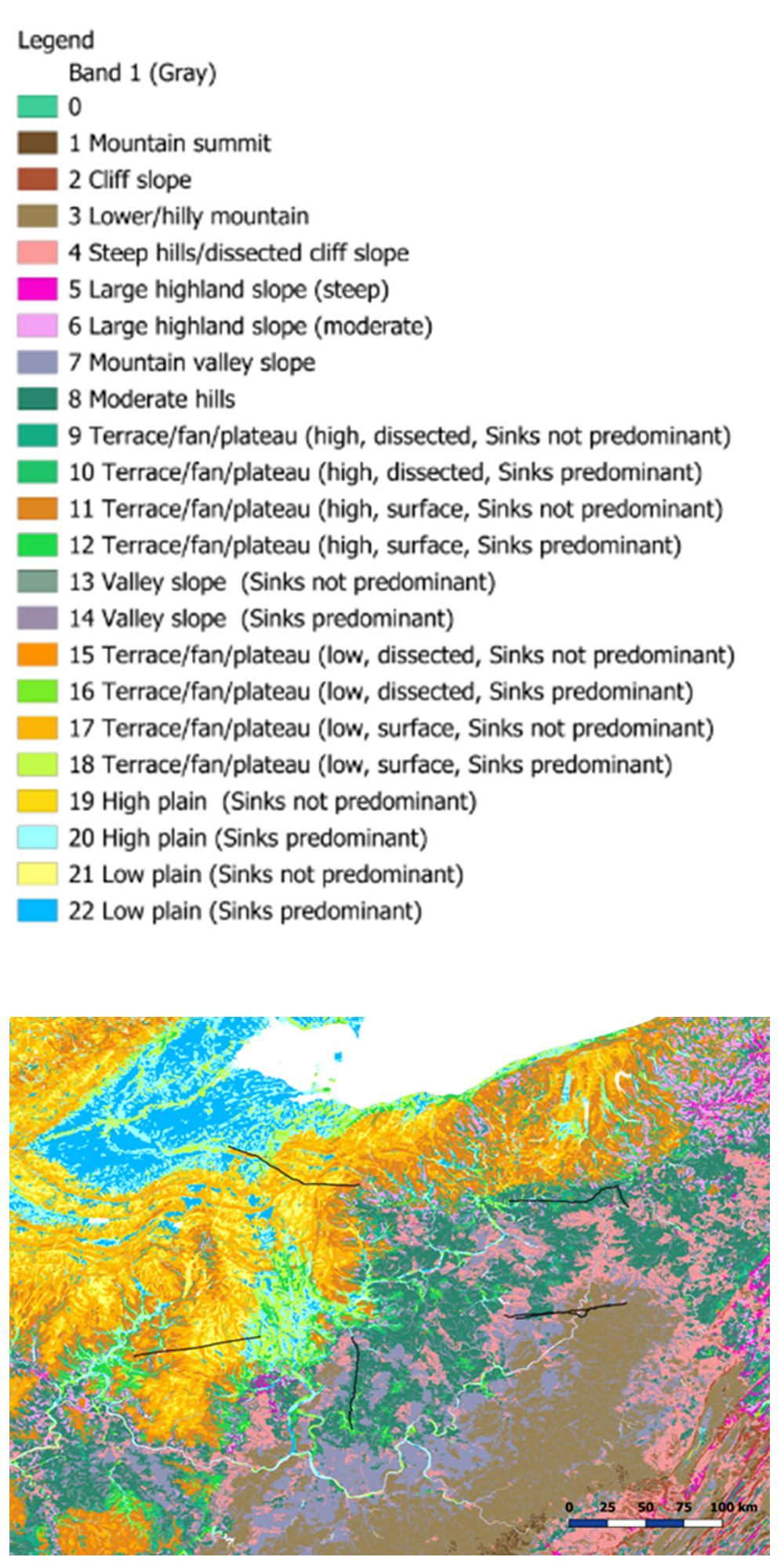
FIG. 1 shows the study of regions across some 150,000 km2 within the states of Ohio, West Virgina and Pennsylvania. The terrain classification data illustrates the variety in terrain across the region studied.
Why this matters for operators. A system like this strengthens geohazard management in several ways:
- Improved prioritization: Resources can be directed toward segments where terrain risk and pipeline vulnerability intersect
- Less manual review: Analysts spend more time interpreting results and less time assembling data
- Improved documentation: The system provides consistent, defensible inputs for integrity decisions—important for regulatory discussions
- Continuous awareness: Geohazard management shifts from periodic checks to an ongoing, data-driven process.
Most importantly, the framework offers operators a clearer, more dynamic understanding of the landscapes their pipelines traverse.
NOTE
ᵃ Rosen’s Integrity Data Warehouse
LITERATURE CITED
1 J. Iwahashi and D. Yamazaki, “Global polygons for terrain classification divided into uniform slopes and basins,” Progress in Earth and Planetary Science, 2022, online: https://doi.org/10.1186/s40645-022-00487-2