
July 2022, Vol. 249, No. 7
Features
Identifying, Minimizing Sinkhole in Pipeline Rights-of-Way
By Richard McDonough, North America Correspondent
(P&GJ) — Kentucky and Pennsylvania are two of the states and commonwealths that have several areas within their borders susceptible to karst formations, including sinkholes and surface depressions. These states also have substantial resources available for pipeline companies – and others – to review when attempting to identify locales with sinkholes as well as areas that are prone to karst formations.
“A sinkhole is a depression in the ground that has no natural external surface drainage,” according to a statement from the United States Geological Survey (USGS) of the Department of the Interior. “Basically, this means that when it rains, all of the water stays inside the sinkhole and typically drains into the subsurface.”
Sinkholes are most common in what geologists call karst terrain, where the types of rock below the land surface can naturally be dissolved by groundwater circulating through them. Soluble rocks include salt beds and domes, gypsum and limestone.
“Sinkholes are dramatic because the land usually stays intact for a period of time until the underground spaces just get too big. If there is not enough support for the land above the spaces, then a sudden collapse of the land surface can occur,” the USGS statement continued.
Thus, a sinkhole.
USGS also noted that sinkholes can be human-induced. “New sinkholes have been correlated to land-use practices, especially from groundwater pumping and from construction and development practices.”
Sinkholes can form when natural water-drainage patterns are changed, while other sinkholes form where the land surface is changed by industry.
Kentucky
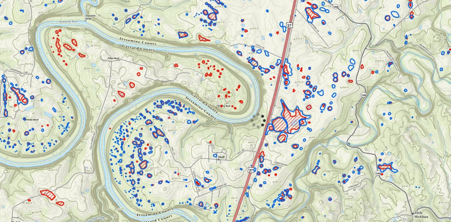
The Kentucky Geological Survey (KGS) has extensive mapping capabilities that identify karst formations and sinkholes. These maps are accessible to the general public by visiting the KGS website.
“Mapped locations of sinkholes can also be viewed online using our interactive Geological Map Information Service at our website,” explained Charles Taylor, groundwater hydrologist and head of the Water Resources Section of KGS. Among maps available are ones identifying sinkholes as determined by topographic maps as well as ones detailed using LiDAR (Light Detection and Ranging).
He stated that technology has helped KGS identify a number of karst formations that had not been noted previously.
“The LiDAR technology has identified three to four times as many sinkholes as compared to the sinkholes identified using topographic maps,” said Taylor. These differences in identification can be seen clearly in the map shown at the beginning of the article.
Pennsylvania
The Pennsylvania Geological Survey (PGS) also provides a wide variety of maps available to the general public. You can view these maps at the PGS website. Some of these maps identify sinkholes as well as surface depressions.

“Basically, a surface depression is a dip or sag on the land surface,” explained William Kochanov in an interview in 2018.
At that time, Kochanov was senior geologist at the Bureau of Topographic and Geological Survey of the Pennsylvania Department of Conservation and Natural Resources; he is now retired. Kochanov noted that surface depressions can be precursors to sinkholes or unrelated; both are possibilities.
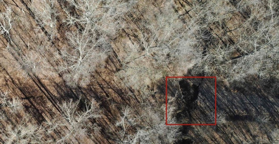
He also stated that aerial maps taken at different points in time can help identify areas of concern. The two aerial photographs below show the same areas of central Pennsylvania at different times.
“One of the images was photographed in 1957, the same area in 1964,” explained Kochanov. “The 1964 image clearly shows darker gray ‘spots’ on the land surface. These represent the karst drains. They retain the moisture of the soil longer because as a karstic surface depression, they hold water, [and] then allow the water to drain internally into the subsurface slowly over a period of time. If the photo was taken at the right time of year and under wet weather conditions (as in this case) these surface depressions can be easily observed.”
Private Companies
Beyond the data publicly available from Kentucky, Pennsylvania, and other governmental entities, many private businesses also are sources of information about sinkholes and other geohazards. SkyX is one of those companies. The firm is headquartered in Toronto, Ontario, and has operations in Canada, the United States, the European Union, and Israel.
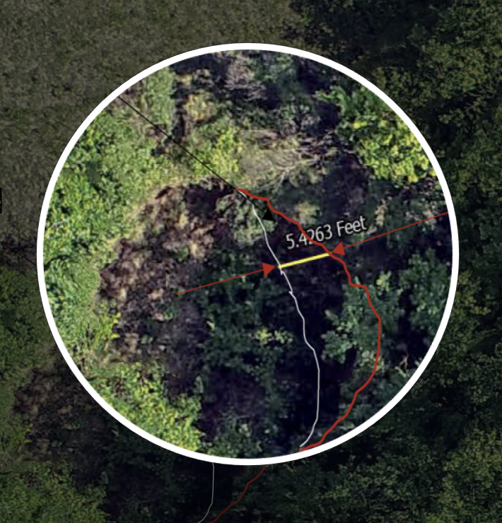
SkyX offers “… a proactive approach to oil and gas asset integrity via long-range aerial data,” according to a spokesperson for the business. “Deploying drones to regularly collect pipeline information from the sky, SkyX allows their customers to quickly note problems with the pipelines, including sinkholes, via a steady cadence of captured images.”
The firm works with many pipeline companies in North America.
“If a pipeline runs over areas that are prone to erosion or underground or surface water activity, sinkholes are more likely to develop or severe pipeline disruptions can result,” stated Jeffrey Jones, vice president of Business Development at SkyX. “A pipeline risks sinking into it, bridging or spanning a newly formed gap, or causing a generally weak infrastructure.”
“There are notable benefits for aerial inspections in these cases,” Jones continued. “The primary benefit is that you can often get into areas that trucks or even people can’t access and see land and the pipeline from the top-down perspective. When you have a top-down perspective and systematic images shot over time, you can easily spot erosion as it starts. Images over time gather layers of data that would go unnoticed by a human eye and allow you to mitigate risk surrounding the disturbed land.”
He explained that aerial inspections of rights-of-way for pipelines by SkyX allows the firm to not only identify sinkholes and sunken ground, but also other key safety-related items. The approach ensures collected data identify potential leaks and other significant issues before they happen, preventing harm to the environment and people. The intelligence also identifies potential hazards on a right-of-way.
Jones explained how monitoring can even work in “swampy” areas through regular monitoring. In one case, regular monitoring found a 10-foot (3-meter) difference in an eroded area and assisted with the flag and mitigation of that problem.
“We don’t know what would have come of that situation if it went unaddressed, but the problem could have been severe,” he said.
Pipeline owners and operators have a number of ways to locate karst formations, including sinkholes, as well as methods to gauge the potential for new sinkholes within pipeline rights-of-way.
Much of the information regarding sinkholes and surface depressions is available through public resources provided by governmental entities. New technology has identified additional existing sinkholes and provided a foundation to enhance the knowledge of areas of concern within pipeline rights-of-way.
Author: Richard McDonough writes on energy infrastructure-related issues in North America. He can be reached at newsaboutamerica@gmx.us.

Comments