
April 2020, Vol. 247, No. 4
Features
Drones Become Additional Inspection Tool in Permian Basin
By David Culler, General Manager Energy-Utilities, PrecisionHawk
The Permian Basin of West Texas and Southeast New Mexico is a key driver of energy growth in North America. Not only does it hold vast economic importance, but it is also one of the most well-studied geologic regions of the world.
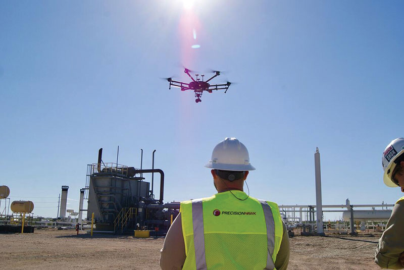
Data collection, inspections and safety within the basin have become increasingly important among oil and gas enterprises there, and drone technology has emerged as a front runner to transform operations. Drones can reduce the number of on-site visits, provide real-time aerial information of vegetation encroachment, leaks and spills, and identify potential safety hazards that the human eye cannot detect.
Traditional methods of field-service inspections have many inherent inefficiencies. For example, data taken by humans do not provide a comprehensive view of total assets, nor is the process efficient. Typically, well tenders, engineers, and environmental experts drive between well pads, pipelines and compressor stations, collecting photographs and taking notes on a clipboard.
This process of data collection has proved to be inefficient, as analysis is left to subjective and tedious manual data review. In the oil and gas industry, efficiency is paramount. An inoperable well pad – whether it houses a single well or multiple – loses revenue for the company.
For example, a 1% change in well pad downtime can result in losses of $600,000 each day. Drones have transformed original methods of data collection in the basin and have elevated the level of productivity.
Commercial drone use is rapidly evolving, with Goldman Sachs predicting its usage will become a $13 billion industry through 2020. While drones can give an engineer eyes in the sky at a safe distance from the asset they are inspecting, the value of drones increases exponentially when a drone can fly for inspections beyond a visual line of sight (BVLOS).
Opening the skies to BVLOS drone operations enables service providers to fly over assets and conduct comprehensive inspections without any human intervention. BVLOS capabilities enable a drone to cover far greater distances, significantly improving the economics and feasibility of many commercial operations.
On-board instruments inform the operator about the position, altitude, speed and direction of the drone. Certified BVLOS drone pilots can change flight parameters and control light detection and ranging (LiDAR) sensors to collect data. In fact, oil and gas companies are increasingly deploying drones in the Permian Basin as part of a complete inspection solution – a unified hardware-software platform that enables them to collect, process, and report on a range of data.
Drones and Data
Drone technology has laid the foundation for data fidelity and accuracy, as managers and asset owners now have the opportunity to collect data at an unprecedented level. Unlike traditional methods of manual data collection, drones can provide precise figures and automate analysis, thus creating a more facilitated and comprehensive process.
Often with helicopter inspections, the quality of imagery can be lacking. Additionally, route and height are key factors for collecting consistent imagery but replicating precise steps with helicopters is next to impossible. On the other hand, drones can repeat routes using the exact same navigation points and height levels.
Asset Management
The introduction of drones has enabled asset managers to be more efficient and to focus on proactive maintenance – mitigating or even avoiding costly downtime. Of the 15 issues that a well tender typically inspects, drones can handle tank gauging, methane detection, and change detection on the well pad including vegetation and intrusion.
According to a report by PrecisionHawk and Skylogic Research, with drones, a well tender can be 30% more efficient by focusing on higher-value maintenance. The real economic value isn’t just cost reduction – it’s in allowing technicians to focus on increasing uptime and allowing them to maximize revenue.
Beyond simply launching an eye in the sky, drones can identify safety hazards that the human eye can’t detect. Drone technology can identify thresholds that may require additional observation. For example, a small fracture in a compressor with a minor methane gas leak may not be easily noticeable. Drones with sophisticated methane detection and range-finding lasers can alert managers of exactly where the problem was detected so they can prepare the tools that will be needed on site.
The nature of well pads makes them difficult and dangerous to inspect. More than 50% of those fatally injured during work were employed by companies that service well pads.
Research from the CDC indicates that between 2003 and 2013, the number of work-related fatalities in the oil and gas extraction industry increased by 27.6%, with 1,189 total deaths. Drones can mitigate this risk by reducing the number of humans who touch dangerous aspects of field-service inspections on well pads.
With drones, the amount of time well tenders spend near well pads is significantly reduced, thereby reducing their exposure to potential injury. Furthermore, by leveraging drones, companies can also reduce the likelihood of vehicle accidents. The Permian Basin is an expansive geographic area that contains a high density of well pads, and the use of drones can dramatically lessen the drive time and risk of vehicle accidents.
Economics of Drones
Drones can have a significant economic impact for oil and gas companies operating on the basin, making operations more efficient while saving money. For example, according to the report co-authored by Skylogic Research, a helicopter or manned aircraft pilot used to collect visual data typically charges $15-$100 per structure.
Conversely, a drone pilot charges $75-$100 per hour, at 30 minutes per structure. For instance, one oil and gas brand determined that the use of drones reduced inspection costs by 66%, from $80-$90 per well pad from traditional inspection methodologies to $45-$60 per well pad using visual line-of-sight drone missions. – P&GJ
FAA Standards
- 107.31 Visual Line of Sight Aircraft
Operation
(a) With vision that is unaided by any device other than corrective lenses, the remote pilot in command, the visual observer (if one is used), and the person manipulating the flight control of the small unmanned aircraft system must be able to see the unmanned aircraft throughout the entire flight in order to:
(1) Know the unmanned aircraft’s location;
(2) Determine the unmanned aircraft’s attitude, altitude, and direction of flight;
(3) Observe the airspace for other air traffic or hazards; and
(4) Determine that the unmanned aircraft does not endanger the life or property of another.
(b) Throughout the entire flight of the small unmanned aircraft, the ability described in subsection (a) of this section must be exercised by either:
(1) The remote pilot in command and the person manipulating the flight controls of the small unmanned aircraft system; or
(2) A visual observer.

Comments