October 2019, Vol. 246, No. 10
Drones & Pipelines
Drones on Deck to Make Pipeline Inspections Safer, More Efficient
By Molly Livingston
There are an estimated 2.6 million miles of oil and gas pipelines throughout the United States – that’s enough to circle the earth about 100 times. Ensuring every mile of these lines is safe and meets industry standards is paramount in order to protect the public.
Often, the task of inspecting the lines is handled by pilots flying small, single-engine aircraft such as Cessna propeller planes. Monitoring these lines from the air is the most effective option, but it’s also expensive, time-consuming and oftentimes risky for pilots who must fly small planes at a low altitude, sometimes in dangerous mountainous regions.
Using unmanned aerial vehicles (UAV) to inspect pipelines is one of the most promising uses of new technologies that our industry has ever seen. Unmanned aerial vehicles, often called drones, can be launched from nearly any location, controlled remotely and programmed to operate autonomously.
Today’s drones are sophisticated aircraft that can manage complex missions, fly farther and achieve more than ever before. They’re a key piece to moving the industry forward and maintaining the safest pipelines possible without any risk to human pilots.
Regulatory Stalls
As with any nascent industry, this promising drone technology is currently weighed down by regulations – the biggest hurdle being that drones are currently not allowed to fly beyond visual line of sight (BVLOS) of the aircraft operator. This limits flights to about a mile, which doesn’t do the pipeline inspection – or really any industry – any good.
In just the last few months, regulators have begun allowing incremental flights which will soon lead to full-scale commercial operations and inspections. This is thanks to the Federal Aviation Administration’s (FAA) focus on crafting new rules that support more complex and low-altitude drone operations. In addition to BVLOS operations, the FAA is working to enable other important mission conditions such as night operations and flights over people.
Beyond infrastructure inspections, the new rules will allow drones to truly take flight and grow various other industries such as commerce, package delivery, insurance, emergency management and agriculture.
Making History
People who follow drone news closely are likely familiar with the FAA”s UAS Integration Pilot Program (IPP), an exciting initiative to accelerate the safe integration of drones into our national airspace. Beginning in 2017, the U.S. Department of Transportation (DoT) and FAA selected 10 teams to participate in the program.
Two of those programs, the University of Alaska-Fairbanks and Kansas Department of Transportation, have recently made huge and meaningful strides for both the aviation and oil and gas industries – taking our industry’s utilization of drones from dream to reality.
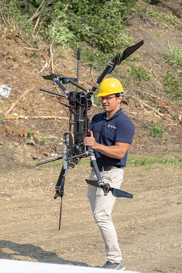
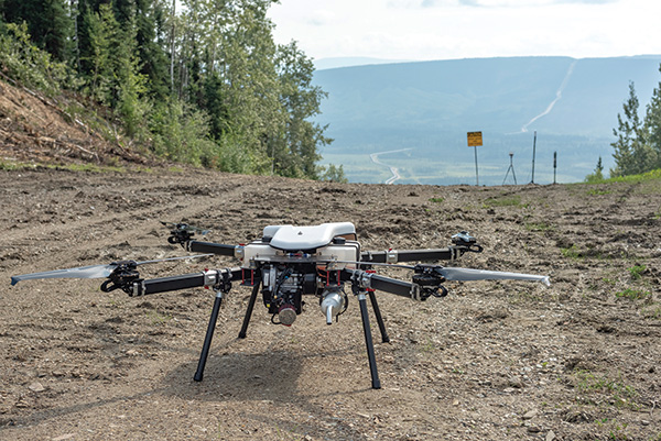
Alaska’s program conducted the first-ever beyond-visual-line-of-sight (BVLOS) drone operation without human observers in August 2019. Routine BVLOS drone operations will do away with expensive and unscalable restrictions on the use of drones for commercial purposes. The August flight was a 3.87-mile mission to inspect the Trans-Alaska Pipeline infrastructure in central-eastern Alaska, outside of Fairbanks.
“We needed software that can see and then avoid another object in the sky in order to enable drones to fly BVLOS,” said Nick Adkins, director of Operations at The Alaska Center for Unmanned Aircraft Systems Integration (ACUASI) “By proving we are able to do this safely, we’ve taken a huge step to enabling meaningful and more cost-effective drone operations here in Alaska.”
This was an industry milestone made possible because of safety avionics company Iris Automation’s detect-and-avoid system paired with ground-based radar Echodyne. Iris Automation serves as the brain of a drone and helps them see the world how pilots do – Iris detects other aircraft, uses machine learning to classify them, makes intelligent decisions, reacts promptly, and truly understands the aviation environment around the drone.
“This flight was the first time onboard detect and avoid technology was approved by an aviation authority as reliable enough to allow for BVLOS drone operations,” said Iris Automation CEO Alexander Harmsen. “We’re grateful for the FAA’s continued push to recognize and understand how these technologies will enable the successful and safe integration of UAS into our lives and businesses.”
In preparation for the historic flight in Alaska, the system underwent 7,000-plus real-world test flights and mid-air collision scenarios, and over 40,000 encounters in simulation. In Alaska Iris was placed on a Skyfront drone, a hybrid-electric multirotor UAS with real-time streaming video that was controlled by a remote pilot up to 60 miles away. The flight lasted for about five hours.
Addressing Challenges
“The cost-benefit of drones ultimately lies in the convergence of three things: safety, autonomy, and endurance. The Alaska flight combined all three,” said Skyfront CEO Troy Mestler. “It’s amazing to see the BVLOS-ready Perimeter long endurance UAV be integrated with safety-critical technologies like Iris’ collision avoidance system.”
Just two weeks after the Alaska flight, The Kansas Department of Transportation’s IPP team built on Alaska’s progress when the FAA granted it permission to conduct the first drone flight beyond the operator’s line of sight using only Iris Automation’s onboard sense-and-avoid systems.
This is notable because a truly useful inspection flight for the oil and gas industry cannot depend on visual observers or ground-based radar in place – the drone must be able to fly as if a pilot is on board, which means seeing the environment around it and reacting automatically to avoid collisions.
The historic flight will be a collaborative effort between Iris Automation, Kansas State University Polytechnic Campus, Westar Energy and KDOT. The 9-mile flight will first inspect power lines, marking a first of its kind for long line linear infrastructure and the first step to enable routine commercial infrastructure inspections across the state.
It’s likely the entire industry will be eagerly watching when the first precedent-setting flight of this nature takes place in October, setting the pace for continued momentum and paving the way for regular and routine drone use in the oil and gas industry. P&GJ
Molly Livingston is a freelance writer

Comments