
December 2016, Vol. 243, No. 12
Features
Drones Soaring as Oil & Gas Monitoring, Safety Tool
The days of conducting an aerial inspection on a pipeline right-of-way, either by helicopter or a fixed wing plane, are coming to an end as pipeline operators around the world are increasingly using drones to monitor, diagnose, maintenance and provide security for networks and installations.
One of the main selling points of drones is they are considerably cheaper and, as sensor technology improves, their ability to detect potential faults and threats to infrastructure and personnel is becoming recognized.
Drone Market
The world market for civilian-operated commercial drones in 2015 was estimated at $500 million and could reach $3 billion by 2020, reports Business Insider. Energy companies, as well as oil, gas and petroleum products pipeline operators, are likely to become significant users and owners of drones for monitoring purposes. North America alone has about 305,000 miles of interstate and intrastate transmission pipelines and associated infrastructure that need regular monitoring, according to the Energy Information Administration (EIA).
Drones can check on the pipeline rights-of-way for signs of possible leaks, such as dead or discolored vegetation, pooling of surface liquid, dirt or debris blowing up from the ground, or unusual fog or clouding. Drones can also provide a safer way to inspect difficult to reach or dangerous locations.
Chief among the driving forces increasing the popularity of drones are the recent technical advances that allow the miniaturization of drones, combined with remarkable advances in the adoption of sensors technology used in recently constructed pipelines. This allows for rapid transmission of data to an engineer who can order repairs or preventative work.
Another major driver, one that is seen around the world, is the need to meet increasingly tougher environmental and operating regulations. Also, there is the significant cost advantage of modern drones. A typical drone equipped with a standard package of sensors, including a heat-sensing camera, can cost as little as $85,000, while a helicopter, doing the same monitoring job, costs $3,000 per flight hour, said Dave Kroetsch, CEO of the Canadian based drone manufacturer Aeryon Labs Inc. Using this scenario, investment in a drone can pay for itself in less than 30 hours of use, a fraction of the cost of a traditional small plane or helicopter.
Compared to conventional monitoring by helicopter, drones have the advantages of high environmental compatibility as they don’t emit CO2, are extremely quiet in the air and provide security in a cost-effective way. Drones are also extremely flexible. They can take off vertically, use a nearby road as a runway or even be launched by catapult. This versatility provides pipeline operators with new opportunities to reduce hazards and improve monitoring effectiveness.
Drones equipped with sensors and cameras can transmit data to a base thousands of miles away and are used around the world, including the Arctic, Africa, North America, Europe and China.
Growing Numbers
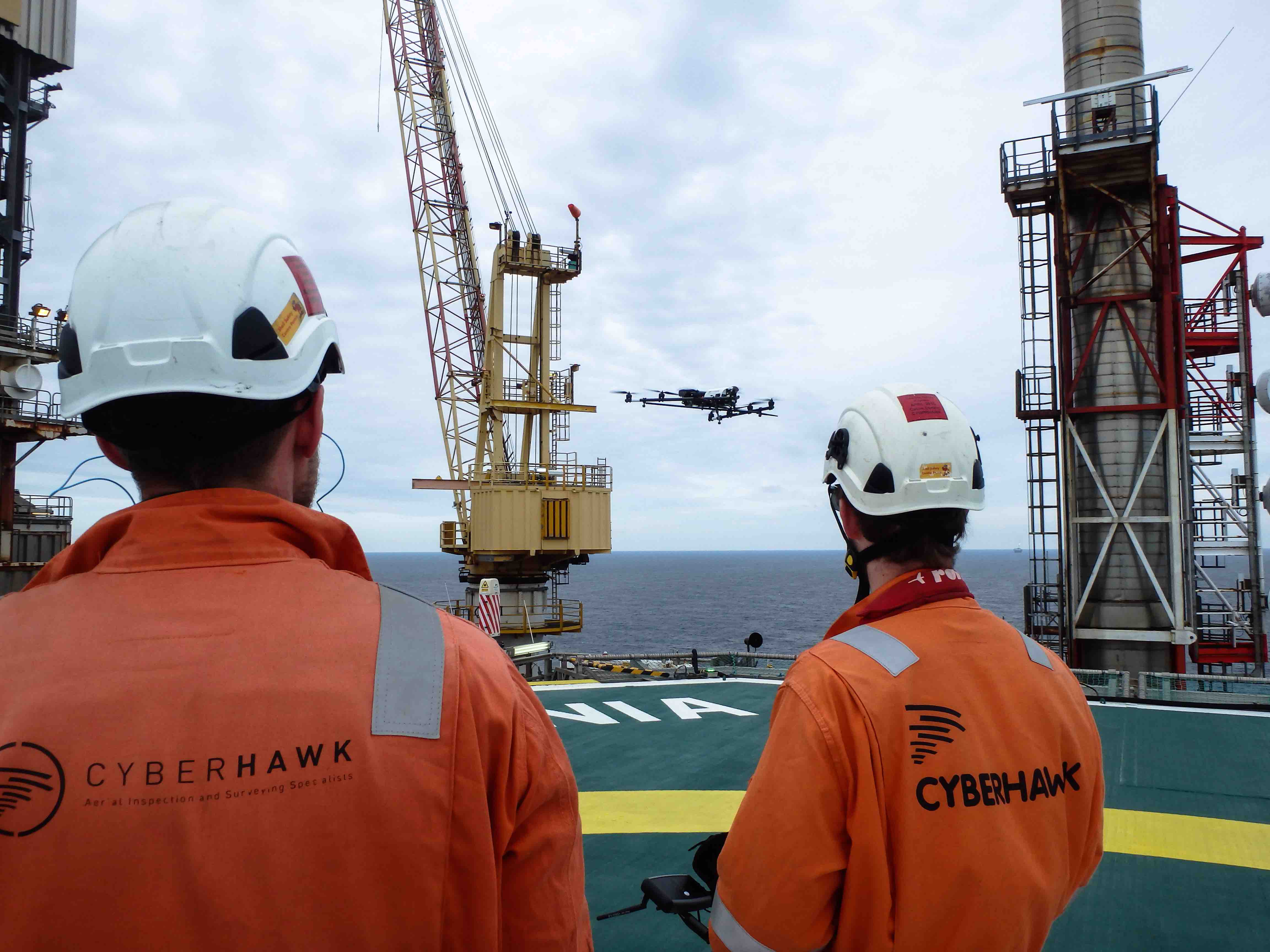
In the United States alone, 500 companies have Federal Aviation Agency (FAA) approval to provide commercial drone services, according to Fortune. Worldwide, there are a number of companies providing specialized commercial drone services for the oil and gas industry. These include drone manufacturers such American-owned Precision Hawk, as well as three British-based companies, Skyfuture, Cyberhawk and Barnard Microsystems Ltd.
The latter is in the process of delivering 500 drones to the Nigeria Security and Civil Defence Corps (NSCDC) to monitor and protect oil and gas pipelines and associated infrastructure against theft and sabotage by militant groups. There are also dedicated service suppliers, for example France’s Air Marine, which specializes in aerial data acquisition and processing. It provides a drone-based pipeline surveillance program for GRTgaz, a European natural gas transmission company that owns and operates the longest high-pressure natural gas transmission network in Europe, according to Oil and Gas Financial Journal.
In North America, drones are being used by several energy companies including BP, which began test flights in the Prudhoe Bay oilfield region of Alaska in 2014. BP is using a radio-controlled line-of-sight, fixed-wing drone that weighs 13 pounds and is 6 feet long. It uses light detection and ranging (LiDAR) equipment and remote sensors to collect 3D images to detect pipeline faults and leaks.
“This is a breakthrough for BP,” said Curt Smith, chief technology officer, in a company video, describing how drones improve field operations at less cost and risk in an environment of floods and ice floes. The drones, made by California-based AeroVironment, enable workers to drive along gravel roads in poor visibility and scan pipelines to identify frost-damaged areas that need repair.
Since February 2015, Tomskneft, a joint venture between Russia’s Gazprom and Rosneft, has tested domestically produced drones in Siberia to detect unauthorized access and monitor the condition of 5,000 km of pipeline routes. The company also uses drones at oil and gas production installations in the Sovetskoe and Vakhskoe fields, according to Rosneft.
Adapted for the harsh conditions of Siberia, where temperatures can range from to 40°C to minus-30°C, the drones carry specialized photo, thermal imaging and video-survey equipment. Cruising at about 70 km an hour (43 mph), each drone can cover 30 square km, and an average flight can last up to 2½ hours during which time the drone can transmit real-time data to a base or record data on a memory card. Drone operators can manually change drone trajectories for return to a site. The results of these field tests will determine Tomskneft’s future drone use.
In Europe, British-based drone operator RSK Orbital, which provides services to energy companies and pipeline route planners, offers preliminary aerial surveys to identify key constraints, such as archaeological or environmental factors, on proposed pipeline routes. The information helps guide decision-making on viable routes, and the virtual site data can be submitted as part of the environmental impact assessments.
Main Obstacles
Essentially, drones have raised two primary concerns: safety and privacy. In North America, the U.S. Department of Transportation (DOT) receives at least 60 incident reports a month from aircraft pilots who have had to change course to avoid collisions.
Other air users, such as the U.S.-based National Agricultural Aviation Association (NAAA) regard drones, as they do birds – potential hazards to pilots of crop dusters and other low-flying craft. NAAA wants drones to be better equipped to avoid collision, a view supported by the Air Line Pilots Association International (ALPAI), a trade union. Then there are privacy concerns raised by various civil liberties groups, including the American Civil Liberties Union.
As a result, across the world governments are introducing regulatory standards for commercial and private drone use. In the United Kingdom, for example, drones weighing more than 20 pounds must be registered by the Civil Aviation Authority (CAA).
In general, the picture is one of governments playing catch-up with the pace of technological change, but it is clear that the prospects for drones are onward and upward.

Comments