
July 2015, Vol. 242, No. 7
Web Exclusive
Declining Rig Count in U.S. Tight Formations
The count for both horizontal and vertical rigs in U.S tight formations has declining drastically from October 2014. This article discuss the declining rig count in the seven major Energy Information Administration (EIA) U.S. oil and natural gas regions.
The rig counts in these seven regions have significantly reduced in number in the recent months and continued to drop for the seventh straight month. The total count as of April is almost equal to that in January 2010. Though the rig count data is available for the past several years, this article looks at the data for the last five years (January 2010-April 24, 2015).
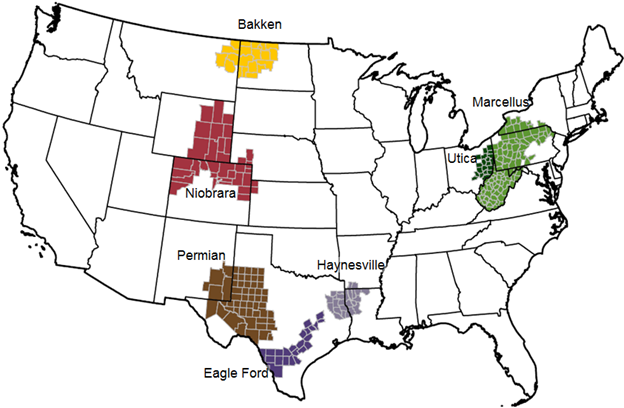
EIA’s Drilling Productivity Report (DPR) regions are delineated along county lines rather than the shale geologic formation borders. To clarify the differences between the shale formation borders and DPR region, consider Utica shale formation and Marcellus shale formation.
Most of the Utica formation is beneath the Marcellus shale formation and stretches across Maryland, New York, Pennsylvania, West Virginia and Ohio. EIA’s definition of the Utica region is the formation in Ohio. The rest of the Utica formation resources are accounted in Marcellus region.
EIA’s DPR and Baker Hughes U.S. Rig Count Report shows the total rig count from the seven major regions have been declining since October 2014. By April 2015, the total count was 665 rigs, down almost 50% since October 2014.
Bakken Region: The Bakken shale formation is primarily an oil play and ranks as one of the largest U.S. oil developments of the last 40 years. Part of the Bakken shale sits inside the United States with the other part in Canada. It runs through two North Dakota and Montana and two Canadian provinces, Saskatchewan and Manitoba, and covers 200,000 square miles.
The Bakken region is a subset of Bakken shale formation and includes only the formation inside the U.S. Bakken region is the Bakken shale in North Dakota and Montana. Bakken region rig count peaked in June 2012 at 218 rigs. In April 2015, Bakken region lost more than half its rig count to 86 rigs.
Eagle Ford Region: Eagle Ford shale formation is located in multiple counties in South Texas and runs from the U.S.-Mexico border at Laredo to north of Houston. It’s about 50 miles wide and 400 miles long. Eagle Ford has both oil and natural gas reserves, predominantly oil. The maximum count for the Eagle Ford region in May 2012 was 279 rigs. The count fell to 137 by April 2015.
Haynesville Region: Haynesville formation is located in the area of northern Louisiana, southwestern Arkansas and eastern Texas. This shale covers about 9,000 square miles. The Haynesville region has lost more than 80% of its count from April 2010 (237 rigs) and 32 rigs in April 2015.
Marcellus Region: Marcellus formation is located in Ohio, West Virginia, Pennsylvania and New York. It also includes small areas of Maryland, Kentucky, Tennessee and Virginia. The Marcellus shale spans 95,000 square miles. Note that the Marcellus region is a subset of Marcellus shale formation and does not include the formation part of Ohio.
The Marcellus region count peaked in January 2012 at 144 rigs. By April 2015, Marcellus region had lost over 40% of its rig count to 82 rigs.
Niobrara Region: Niobrara shale formation is located in northeastern Colorado, with parts of formation trending into neighboring states – Wyoming, Nebraska and Kansas. Niobrara formation has both oil and natural gas reserves.
The maximum rig count for Niobrara region in October 2014 was 109 rigs. The count came down to 50 by April 2015, which is almost down by 50% when compared to its maximum count.
Permian Region: Permian Basin is located in West Texas and southeastern New Mexico. The greater Permian Basin is actually comprised of several basins – Midland Basin (largest), Delaware Basin and Marfa Basin (smallest).
The area extends about 250 miles wide and 300 miles long. In November 2014, Permian region had 565 rigs. As of April 2015, the rig count was 263.
Utica Region: Utica is located in significant portions of Ohio, Pennsylvania, West Virginia, New York, Quebec and other parts of eastern North America. Utica region is only the Utica formation and includes only Ohio.
The other parts of Utica formation in Pennsylvania, West Virginia and New York fall under Marcellus region. The maximum count for Utica region came in October 2014 with 30 rigs, but had fallen to 15 by April 2015.
Conclusion
Oil and natural gas production is also dependent on several rig and drilling factors, including rig count, drilling efficiency and production declines. The rig count alone may not give a clear picture about the raise or drop in oil and natural gas production. But the rig count data is a crucial indicator in giving us an idea on the direction of future U.S. oil and natural gas production.
Author: Chandra R. Munagavalasa works at SunGard Energy as a manager in software development in Houston. He earned his master’s degree in industrial management from IIT-Madras and is certified as a PMP, PSM I, PMI-ACP and SSGB. He can be reached at chandra.munagavalasa@gmail.com.


Comments