March 2014, Vol. 241 No. 3
In The News
EIAs Expanded Mapping Tool Shows Location Of Oil, Gas Wells Across U.S.
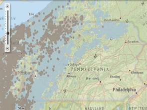
The Energy Information Administration (EIA) expanded its U.S. energy mapping system tool to include the location of producing crude oil and natural gas wells developed across the nation. The new feature is the first of its kind and allows users to see most crude oil and natural gas wells developed in the U.S.
By enabling the “Oil and Gas Wells” feature in EIA’s energy mapping tool, individuals can view producing wells located over a broad geographical area, such as a producing oil or natural gas field. Users can visually inspect wells in their state, county, congressional district, or even neighborhood. When the tool is used with a satellite view, users can see satellite pictures of individual wells.
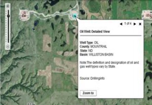
EIA’s expanded mapping tool shows offshore and onshore wells in areas where crude oil and natural gas production is being developed. This includes areas like Pennsylvania, North Dakota and Texas where crude oil and natural gas development in shale basins has increased significantly in recent years. With the release of this tool, the public, policymakers, energy experts and other stakeholders can easily track oil and natural gas field development over time.
The new mapping feature is made possible by a partnership between EIA and Drillinginfo and can be found on EIA’s State Energy Profile webpage: http://www.eia.gov/state/maps.cfm

Comments