September 2009 Vol. 236 No. 9
Features
The Geospatial Dimensions Of Critical Infrastructure And Emergency Response
The 2009 edition of “The Report Card for America’s Infrastructure” was published by the American Society of Civil Engineers (ASCE) in late January, its release date accelerated in an effort to influence the debate over the enormous economic stimulus bill then being negotiated by the Obama administration and Congress. It should be no surprise to anyone that the major infrastructure assets in the 15 categories examined fared no better than they did in the 2005 Report Card.
As in previous versions, the report included the critical infrastructure areas of energy, bridges, dams, drinking water, roads and transit, wastewater and several other areas. For the first time, levees were considered as a separate infrastructure category. Security, which had been treated separately in the 2005 report, is now being viewed in the context of resilience – the ability to withstand and recover from natural and man-made hazards. As such, resilience has been integrated into the grading within each category.
Since the last report, while some categories showed improvement, the overall status of the nation’s major infrastructure assets was again rated a “D.” The bill for remediation of this problem, however, grew from $1.6 trillion to $2.2 trillion.
The Geospatial Information & Technology Association (GITA) is extremely concerned about the current status of the nation’s infrastructure and ways to begin to address this increasingly serious problem. There are serious social, political and economic development considerations that impact our ability to make progress in this area — and severe ramifications of our failure to do so. GITA defines infrastructure as “all fundamental services, activities, and operations that sustain our communities and way of life.”
GITA is fully committed to advancing the use of geospatial technology to address our infrastructure problems. GITA’s members and constituents — professionals in the gas, electric, water/wastewater, pipeline, telecommunications and local, state and federal government sectors — are using geospatial solutions on a daily basis to do just that.
In late 2008, the GITA Research Committee undertook an effort to address “Geospatial Dimensions of Critical Infrastructure Protection and Emergency Response.” The first step was to promote better understanding and communication about how a failure or an event in one infrastructure sector may affect assets in others – how all infrastructure is ultimately connected. A seminal White Paper on “Interdependencies of Infrastructure” was developed to form the basis for further exploration of this concept.
The next phase of this project is to delve into each of the major vertical industry areas represented by GITA’s members and constituents in order to define and discuss these important connections, how these interdependencies might influence the ways in which we respond to our infrastructure crisis, and the emerging key role of geospatial technology in protecting our critical infrastructure and improving emergency response.
This White Paper on “Oil and Gas Pipeline Infrastructure Interdependencies,” is one of several sector-specific views of the importance of understanding how our infrastructure is connected.
Critical Infrastructure Protection
The nation’s gas utilities and oil companies continue to examine their security practices, perform vulnerability assessments, and make appropriate enhancements to their security programs. Such enhancements include supplementing current emergency plans with terrorist risk elements, strengthening physical barriers, tightening control access, adjusting frequency of patrols – both physically and virtually – and confirming response and recovery actions with local law and emergency officials.
In some sense, the term “Critical Infrastructure Protection” is a misnomer. Since disasters are, from the point of view of critical infrastructure, inherently random in nature, not all critical gas and oil infrastructure components can be protected. No fail-safe methods, technologies or approaches exist that can eliminate all conceivable risk to critical infrastructure. Natural events will still occur, accidents will still happen and committed terrorists will still succeed. Even with continuous monitoring and surveillance, complete threat interdiction remains an elusive and unrealistic goal.
Additionally, because gas and oil pipelines are often accessible, no realistic strategy can eliminate the facility’s risk exposure. Moreover, trying to identify all possible exposures of all possible threat events across all critical components and forecasting all possible consequences is an impossible task. Each piece of critical gas and oil infrastructure has unique physical and performance characteristics, managed by private sector companies; each threat to an infrastructure poses unique risks and consequences.
Although total protection of the critical infrastructure remains an unrealistic ambition, disaster managers can adopt strategies to better reduce the impact of natural or man-made events. These strategies typically include pre-disaster preparedness, emergency response, disaster recovery and long-term mitigation activities. The goals of Critical Infrastructure Protection are more realistically set to minimize the consequences of a disaster through timely event notification, information-driven responses, prepared first responders and citizens and pre-planned and rehearsed contingency activities. Private sector, federal, state and local officials have different roles in disaster response, homeland security and terrorism-response situations.
Gas And Oil Pipeline Critical Infrastructure Interdependence
Gas and oil infrastructures have a number of interdependencies and dependencies with other infrastructure that must be considered when identifying and classifying critical infrastructure, developing response plans, and in addressing other issues of security and protection. Figure 1 depicts the interconnectedness of the critical gas and oil infrastructure with water and wastewater, electric, communications, and transportation infrastructures.

Figure 1: Gas and Oil Infrastructure and Interdependencies
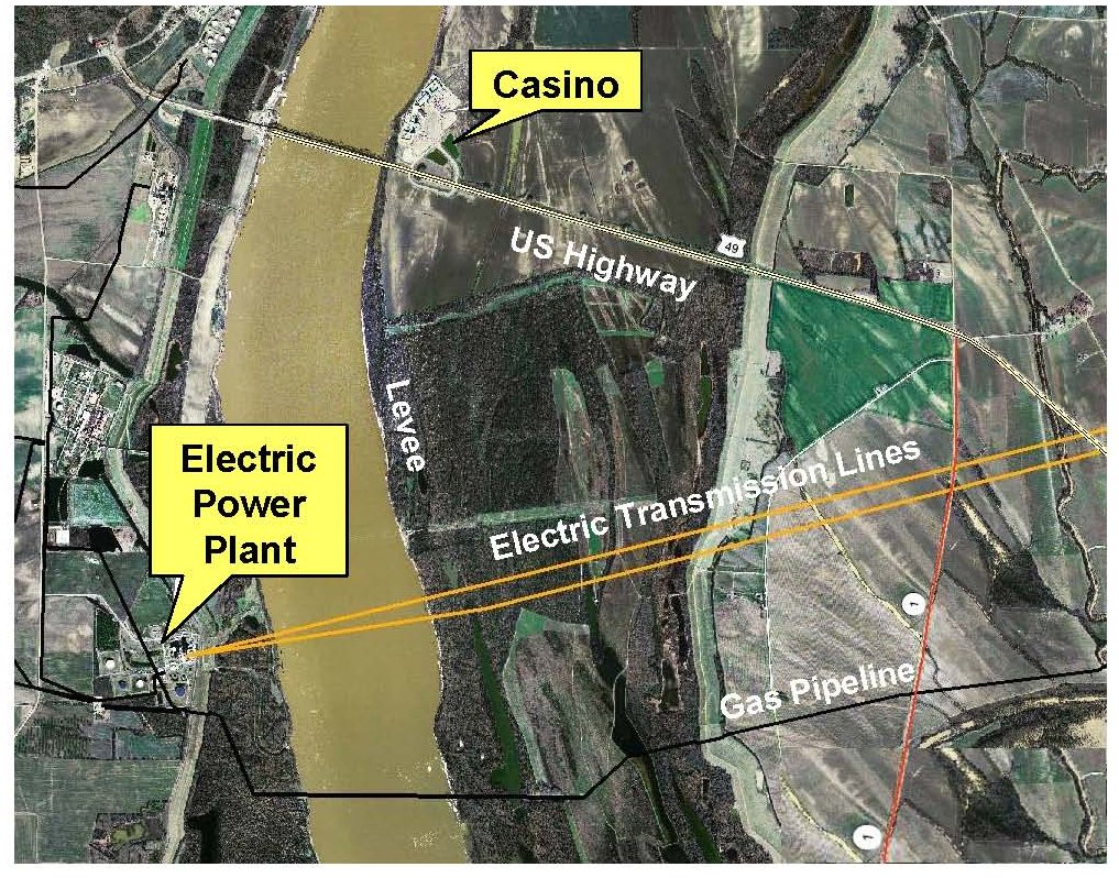
To illustrate the concept of critical infrastructure interdependencies, Figure 2 shows an area in which two significant natural gas lines cross the Mississippi River near Clarksdale, MS. These pipelines pass under the river and, in order to maintain the integrity of the flood-control structure, pass over the levee, buried just below the surface. On the Mississippi side of the river, a major casino complex can be noted in the photograph just to the north of the Helena Bridge, one of only two surface road crossings between Memphis and Vicksburg. On the west side, an electric generation facility powering two 230-KV power lines is noted.
While a failure of the levee at this location due to a flood would be disastrous, a well-planned and executed terrorist attack that exploded a truck bomb above the gas lines where they cross the levee at a time when the river was at a flood stage similar to that experienced during March 2008 would be catastrophic. The consequences of such an event would entail the loss of a majority of the U.S. rice crop and a severe blow to other agronomic interests, a complete halt to traffic on the Mississippi River (about 1/3 of the U.S. GDP passes this pipeline crossing each year), and untold loss of life and property.
Figure 3 depicts the intersection of a 500-KVa electric line from Tennessee Valley Authority’s Brown’s Ferry nuclear reactor supplying Memphis and a major oil pipeline that is part of the Strategic Petroleum Reserve system. This location is a few miles north of New Albany, MS and near the proposed site of a new automobile production facility. This area has suffered severe drought for the past several years and is a region in which wildfires are reaching epidemic proportions.
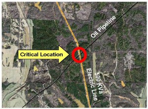
Figure 3: Oil Pipeline and 500 KVa Power Line Intersection Near New Albany, MS
A wildfire at this location or placement of an explosive device would again create havoc. It is likely the most difficult challenge would be to describe the location in order to dispatch emergency personnel and equipment in responding to an event at this location. The closest paved road providing access to the pipeline right-of-way is more than a mile away.
Emergency responders, disaster managers and Homeland Security personnel are often poorly equipped to respond to such events and help to limit the consequences because geographic information about local infrastructure (water, fuel, alternate power supplies, kitchens, shelters, staging areas, etc…) is severely lacking in rural areas. While some federal efforts, such as the Homeland Security Infrastructure Protection (HSIP) data set, have made modest headway at great financial cost, accurate information that is regularly maintained and locally driven is difficult to obtain.
These types of local infrastructure information – needed to plan for, mitigate, respond to, and recover from a disaster – may only be found with limited scope and accuracy through a limited number of local individuals or entities. It is important to note that to protect infrastructure of national importance, data about infrastructure of local importance must first be collected and maintained.
Critical Infrastructure Cascading Consequences
While the interdependencies within an individual infrastructure network such as gas or oil transmission systems are often well understood, the influence or impact that one infrastructure may have on another is the focus of interest in interdependencies and effects modeling. The key effects to model and understand are the chains of influence that cross multiple infrastructure sectors and precipitate potentially unforeseen effects.
As depicted in Figure 4, these chains are composed of multiple interdependency types. They constitute the connections between infrastructure nodes. These particular connections represent the cascading consequence of the effects of an emergency in specific infrastructure areas.
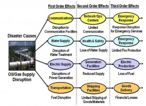
Figure 4: Critical Infrastructure Cascading Consequences
It is impossible to adequately analyze or understand the behavior of a given infrastructure in isolation from the environment or other infrastructures. Multiple interconnected infrastructures and their interdependencies must be considered in a holistic manner. Because of its inherent capability to define and analyze the spatial attributes of virtually every infrastructure asset, geospatial technology is ideally suited to identifying these interdependencies and then modeling effective responses.
Conclusion
It is important to recognize that our infrastructure assets are inexorably tied together in myriad ways in a vast network that provides the foundation for our quality of life, economic well-being and overall security. An understanding of these relationships, or interdependencies, is crucial to effective response, mitigation and recovery in times of emergencies caused by natural occurrences, or those resulting from intentional or accidental human activity.
Acknowledgment
The authors, David DiSera, CIO of First Insurance Company of Hawaii and Talbot Brooks, Director of the Center for Interdisciplinary Geospatial Information Technologies, Delta State University, gratefully acknowledge the support provided by the Geospatial Information & Technology Association for this research. Any opinions, findings, conclusions, and recommendations expressed here are those of the authors and do not necessarily reflect those of the Geospatial Information & Technology Association. For more information on the “Geospatial Dimensions of Critical Infrastructure and Emergency Response White Paper Series” and related initiatives, contact GITA or visit www.gita.org.

Comments