
August 2017, Vol. 244, No. 8
Features
Advanced Remote Sensing Offers Key to Identifying Pipeline Risks
With over 2.9 million miles of pipeline transporting natural gas, oil and other hazardous liquid across the United States, ensuring public safety and infrastructure security is of the utmost importance.
High-profile incidents such as the 2010 San Bruno pipeline explosion and the natural gas leak at the Aliso Canyon underground storage facility underscore the impact of problems caused by pipeline failures.
Current remote-sensing technologies are making it easier and more cost-effective for utilities to continually survey assets, inspect for problems and proactively address potential concerns.
It only takes a quick glance at the headlines to understand the importance of maintaining pipeline assets. Remote sensing technology plays a vital role in inspecting and monitoring existing pipeline rights-of-way, surveying and evaluating new pipeline construction routes, and planning new civil engineering projects to improve pipeline resiliency, particularly in geographic areas that are hard to reach or traverse.
Pipeline operators increasingly rely on a wide range of remote-sensing solutions to aid with routine maintenance activities and long-term infrastructure planning.
This article explores the various technologies being employed for remote sensing and how this is enabling new capabilities not possible with traditional inspections processes, more efficiently and at a lower cost.
Technological Revolution
Remote-sensing capabilities are revolutionizing how pipeline operators monitor, maintain and conduct future planning for their infrastructure. Among the advanced remote-sensing tools available to them today are:
- Orthographic imagery – more generally referred to as aerial photography, today’s orthographic imagery can be collected using cameras on unmanned aircraft systems (UAS) and produce clear images down to the centimeter level. This granular view from the sky can provide pipeline operators with accurate and up-to-date views of their land base, helping them understand conditions in the field as well as enabling them to do virtualized high-consequence area (HCA) evaluations and class coding, and conduct encroachment analysis.
- LiDAR – this consists of light detection and ranging (LiDAR) blankets pipeline corridors in 3-D point clouds capable of penetrating vegetation canopy. The lasers on aircraft or UAS send pulses to the ground which enables users to establish precise elevation values. In addition, collection of GPS and inertial measurement unit (IMU) data at the time of laser scanning enables the resultant point cloud to achieve accuracies within a few centimeters in X, Y and Z dimensions. LiDAR supports many of the same applications as orthographic imagery, but offers additional data for 3-D encroachment analysis, geohazard monitoring and aboveground pipeline structural integrity. By doing LiDAR surveys on a regular basis, pipeline operators also can examine changes over time and use the analysis of the data to determine areas where there is a critical need for maintenance or potential safety concerns.
- Hyper-spectral imaging – this type of imaging measures light energy across hundreds of indi-vidual spectra with images containing 200 or more contiguous spectral bands. Images produced from hyperspectral sensors contain much more data than those from multispectral or traditional RGB sensors, returning unique “signatures” for the different objects below. Hyperspectral imaging enables pipeline operators to differentiate between tree species and surface mineral content, and can help identify methane leaks.
- Thermal imaging – this technology measures the heat given off by an object to produce an image or locate it. Pipeline operators are now beginning to use thermal imaging to identify and quantify leaks.
Use of one, or a combination, of these remote-sensing technologies enables pipeline operators to eliminate costly, time-consuming foot patrols, which often cannot cover the entire span of the infrastructure on a regular basis. These technologies make it easier for operators to identify structures on or adjacent to pipeline right-of-way, and conduct HCA and code-classing analysis to mitigate safety risks and maintain regulatory compliance from a structural perspective.
With data derived from these surveys, pipeline operators can create HCA vectors based on U.S. Department of Transportation (DOT) guidelines and can assess potential impact radius (PIR), which is the distance from a potential explosion point at which death, injury or significant property damage could result.
New Applications
While remote-sensing technologies deliver data more quickly than traditional foot patrols and conventional inspection methods, the most exciting aspect is the new applications these solutions support.
Pipeline operators are getting insight and situational awareness never before available for tasks such as:
Methane leak detection using a combination of hyperspectral and thermal imaging is now possible at distances far greater than the close proximity required by “sniffer” technology. No longer does the methane-sensing device need to physically pass through the plume created by a leak.
As reliance on natural gas increases, savvy pipeline operators are willing to invest to minimize methane loss and avoid leaks of any size. Use of these imaging technologies have potential practical applications in improving safety by identifying hazardous venting situations, aiding exploration and deposit development, and improving gas transmission efficiency by supporting easier leak identification and mitigation.
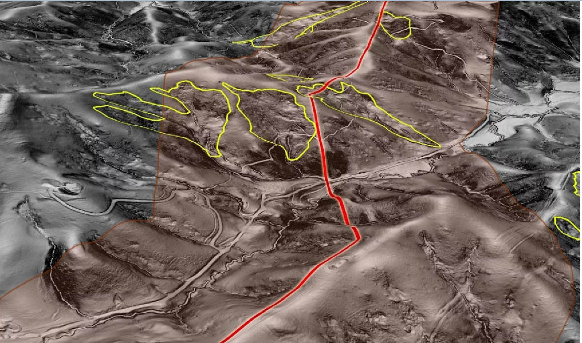
Geohazard identification has traditionally been performed via site visits in the field which come at great expense and effort. LiDAR technology has proved superior in its ability to identify areas of current and projected terrain failure.
- Geohazards are prominent along pipeline rights-of-way. In fact, some companies have reported as many as 500 landslides that could affect their infrastructure.
- Even the most knowledgeable certified geologists cannot see geohazards obstructed by vegetation, and site surveys only provide insights into a few data points, often looking only at known hazard areas. LiDAR can penetrate dense vegetation canopy and ground cover to reveal subtle and large-scale surface features, such as erosion and deposition.
- Remote-sensing technology also can provide total coverage of all pipeline rights-of-way in a fraction of the time it would take field crews, enabling geologists to spend time making actionable decisions as opposed to hiking up and down pipeline corridors. With LiDAR, pipeline operators can better mitigate risk and gain greater awareness into the landscape around infrastructure, enabling them to be proactive in addressing these types of hazards.
- Aboveground pipeline integrity analysis has increasingly become a concern in northern latitudes, such as Alaska, as the permafrost thaws. LiDAR scans can be used to determine if and where structural shifting has occurred or may occur in the future. Pipeline operators can compare original construction design, with “as-built” information and real-time LiDAR surveys, to quantify the changes that have occurred over time.
- Traditional pipeline integrity analysis requires multiple full-time employees doing physical inspections, a process that could take over a half year for a single pass along the full length of the pipeline. With LiDAR, entire system surveys can be conducted in a matter of weeks, depending on total mileage, significantly reducing labor costs and danger to employees.
- Change detection enables pipeline operators to isolate identifiable features – such as vegetation growth or effectiveness of maintenance – captured by LiDAR surveys year-over-year. The evaluation of current and historical LiDAR data also allows pipeline operators to quantify or compare the impact of new construction, evaluate mitigation efforts and identify potential issues with publicly constructed encroachments, such as sheds and desks.
Remote-sensing technology has the potential to provide great value and analytic insight to oil and gas pipeline operators today and for years to come. The combination of virtualized inspections and new applications delivers situational awareness that was unimaginable just a decade ago, leading pipeline operators into a new era of data-driven decision-making and management.
Author: Logan McConnell is a pre-sales engineer at Quantum Spatial Inc. (QSI), where he focuses on private and energy business development and marketing.

Comments