
October 2016, Vol. 243, No. 10
Features
Advanced Mobile Leak Survey Technology: An Operator’s Perspective

It was a cold dark night…
Not the right time to perform a leak survey? Think again. This is only one of the many considerations that must be explored when testing, designing processes and implementing the advanced mobile leak survey technologies currently available to gas utilities. More on understanding the science behind the technology later.
Federally mandated gas leakage survey has been an integral part of the safe and reliable operation of gas utility infrastructure for many years. Although the technology and performance of the handheld instruments used to perform these surveys has improved greatly over the last 10 years, the manual process of conducting the survey has essentially remained the same.
Surveyors carrying leak detecting equipment must periodically walk the assumed location of all underground pipelines testing for any signs of leakage. This is labor-intensive and subjective in nature, relying on the experience of the surveyor to know where best to perform the survey.
Let’s examine a case study: The distribution main runs under the center of the sidewalk in a non-wall to wall paving environment. Does the surveyor choose the back edge of the sidewalk, assuming that it is the most likely location for any underground leakage to migrate and vent at the surface allowing for detection? At the curb? The edge of the street paving? The middle of the street? Or, even 10 feet behind the sidewalk?

All of these could be potential venting locations under the right conditions. The unpredictability of the migration pattern of an underground leak as the escaping gas travels through the soil can cause gas to vent many feet from the actual leak location. To physically perform a walking survey to test the atmosphere at all of these potential locations would be cost-prohibitive.
Advanced Mobile Leak Survey Technology
So, you have the same situation and the same surveyor; only this time they are operating a vehicle-mounted advanced leak survey system. The surveyor drives the same streets and pipelines that would have been walked to perform a traditional survey. This time the technology is testing the atmosphere for the presence of methane and potential leakage from all of these venting locations simultaneously at vehicle speeds of 15-25 mph.
At the conclusion of the driving survey, reports are generated mapping methane indications and the likely source locations to be subsequently investigated on foot using traditional survey instruments, methods and procedures.
This results in a more efficient survey by concentrating the effort at locations where methane is present. Now it becomes feasible to perform a thorough search, testing the atmosphere in all potential venting locations, until the source of the methane is found. The surveyor becomes a leak investigator with the added knowledge that a leak exists in the area. Productivity is gained by eliminating work in areas where no presence of methane is detected.
More on Science
The technology was designed to measure greenhouse gases (e.g. methane and carbon dioxide) in the parts per billion range. Partnerships between the utility industry companies like PG&E, CenterPoint Energy and the scientific community have led to the development of the processes necessary to integrate this technology into a robust leak-survey program.
Climate science and the collective research into the atmospheric transport of greenhouse gases has provided the basis for the algorithms that drive the leak indication software behind the technology.
With known characteristics of methane molecules and how they react to certain environmental conditions, a calculation can be made to predict the probable source location. Methane molecules have a tendency to stay chained together for longer periods of time during low light and lower temperature conditions. Conversely, when methane is exposed to bright sunlight and higher temperatures the molecules disperse rather quickly. Also, atmospheric conditions typically stabilize after sunset. For these reasons it is recommended that surveys be performed between an hour after sunset and sunrise to obtain best results.
How It Works
The equipment components include:
- Greenhouse gas analyzer, tuned to detect methane
- Sonic anemometer
- Global Positioning System (GPS)
- External pump and intake system
- Data processor and software
- Proprietary algorithms
- Reports generation
During the performance of the survey, the pump is continually drawing external air through the intake, supplying the analyzer with atmospheric samples from the upwind direction for measurement. When detection is made, the algorithms process the GPS coordinate along with the wind speed and direction from the sonic anemometer to provide a methane-indication investigation area. The algorithms also calculate the survey coverage area. This is determined by evaluating the atmospheric conditions and the likely distance methane molecules would be transported during those conditions.
The technology also provides the ability to view the survey in real time from mobile command or dispatch centers. This includes survey vehicle locations, atmospheric conditions, survey progress, methane indications and survey coverage areas.
At the conclusion of the survey, reports are generated detailing each methane indication. They include the amplitude and location of the detection and the area to investigate to determine the source. Indications can be layered on a gas distribution map for use in the follow-up investigations. Each indication is investigated using traditional survey instruments in accordance with each utility’s standard practice to determine actual location and grade of any associated leaks.
Any areas not covered by the technology, such as downwind from the vehicle at the time of the survey, would be considered a “gap” and have to be surveyed in accordance with existing standards and methods. An area can be driven multiple times, varying the time or on different days to experience changing conditions and wind patterns, to achieve better survey coverage.
Verifiable, Traceable and Complete Records
The technology reporting provides a proof source of the vehicle location in the form of a “line on the map” via GPS bread crumb trail of the vehicle path traveled during the survey. This is layered along with a depiction of the survey coverage area and all methane indications found during the course of the survey. All investigations resulting from this reporting and any gap surveys performed become part of the final documentation package to meet the requirements of a verifiable, traceable and complete survey.
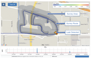
Illustration courtesy of ABB
3-Stage Introduction
Stage 1 – The technology demonstration.
Performing leak survey in a small area in conjunction with traditional survey allowing the operator to become familiar with the technology and the results.
- Set up command center to view survey real time while in progress.
- Perform technology survey, same day early morning hours before traditional survey.
- Review results of traditional survey in comparison with the reports generated by the technology survey.
- Perform follow-up investigation of any indications from the technology survey reporting not found during traditional survey.
- Prepare a white paper detailing the process and results.
- Beginning of the change management process.
Stage 2 – Performing a directed field trial.
Perform a double-blind test in a larger area to evaluate the effectiveness of the technology vs. traditional leak survey. The area chosen should be a representative sample of the average characteristics of the utility’s pipeline material types, age, construction methods and service density. The test should establish:
- Project scope and pilot area
- Double-blind test protocol
- Key performance indicators
- Go/no go criteria
- Introduction to state regulators
- Pilot execution
- Preparation for a white paper detailing the process and results.
Stage 3 – Implementation
- Develop training, standards, qualifications and work procedures
- Establish controls
- Provide training and qualifications for the operators
- Seek concurrence from state regulators
- Educate the public and community leaders about this new activity
- Develop leak survey schedules incorporating this technology
- Perform organizational readiness assessment
- Begin survey with this new technology
- Evaluate controls
Now You Are Ready
You have performed all of these steps in a comprehensive approach in your effort to introduce new technology into a utility environment to perform federally mandated compliance leak survey. You are finding and fixing more leaks than ever before, leading to a safer system for your customers, communities and employees. You are making informed decisions in your DIMP and TIMP programs, armed with detailed information of the actual condition of the facilities you maintain.
It was a cold dark night … and your leak surveyors were out there making the system safer!
Author: Tim Arterberry has 39 years’ experience and 22 years in leadership at a major gas and electric utility with extensive knowledge of gas distribution including leak survey and repair, codes and standards, training development and delivery, regulatory compliance, and safety.

Comments