
February 2020, Vol. 247, No. 2
Features
Mexico’s Pipeline Route Poses Terrain Hurdles
By Mauro Nogarin, Contributing Editor
According to the analysts for the Federal Electricity Commission (CFE), the consumption of electricity in Mexico will grow at an annual rate of 2.6% through 2031, largely due to constant population increase, expected to reach 138.4 million by the end of that period.
This, along with the economic growth of the central region of Mexico, has led to the construction of the Villa Reyes-Aguascalientes-Guadalajara gas pipeline, a 329-mile (529-km), 36-inch (914-mm) pipeline, with a capacity of 886 MMcf/d (25 million cubic meters).
Carbon steel ducts built to API 5L X70 specifications are designed for 1,440 psig (99 bar) and a 30.3-mile (48.8-km) branch of 20-inch (508-mm) pipeline with a capacity of 886 MMcf/d will provide natural gas to CFE power plants in the State of Jalisco and to the Tula-Villa de Reyes pipeline.
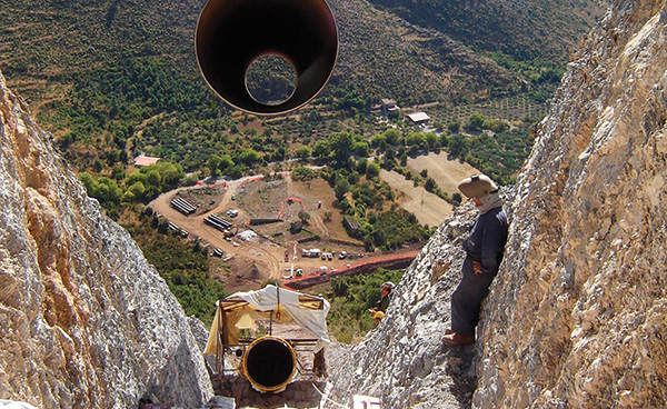
From a terrain standpoint, the area provides several difficulties, including the change in altitude, which ranges from 153 feet (1,830 meters) at its highest point to 138 feet (1,660 meters). The land is characterized by hills, mountains and derivations of the Sierra Madre Occidental.
The flat areas have tables, plateaus and several valleys, areas generally associated with relatively old river networks with moderate river fittings.
The project also presents operational difficulties due to the 33 water currents that cross the area, three of which are permanent flow (Río Verde and El Refugio) and 27 are intermittent. The predominant rock in the Northern High Region is sandstone (40.3%), an epiclastic sedimentary rock consisting of minerals with fragments.
The system will cross nine roads with a total length of 0.62 miles (2.5 km). The most important of them is Federal Highway 9, which is two lanes. There are also 29 minor road crossings.
A pipeline commencing at an interconnection receipt point is anticipated for Mexican territory near Villa de Reyes, San Luis Potosi, with an intermediate interconnection point near Aguascalientes City. It will end at power plants in Guadalajara City, state of Jalisco, and the interconnection point will end at the Energia Occidente’s Manzanillo-Guadalajara gas pipeline.
The route of the 36-inch pipeline will start from the municipality of Villa Reyes, located in the state of San Luis Potosí, and will run to the municipality of El Salto Jalisco. There will also be a branch of 30 miles (48 km) of 20-inch pipeline that will run from El Salto to the municipality of Jocotepec.
A total of 86 special crossings will be made along the route of the pipeline, including the branch. In those crossings with primary and secondary roads, the techniques of tunneling and directional drilling will be used to safeguard the infrastructure.
The interconnection to the Tula-Villa de Reyes pipeline and the La Laguna Aguascalientes pipeline requires a flanged connection.
The interconnection to the compressor station is located in Villa de Reyes. Construction will include the 36-inch pipeline, including the installation of nine 36-inch sectioning valves and the pipeline of the 20-inch branch, including the installation of one 20-inch sectioning valve.
The metering, regulating and control station (EMRyC) is located at the end of the pipeline and will include two 16-inch (406-mm) ultrasonic metering units.
Pipeline Specifics
Investment: $293 million
Progress of construction: 87% complete
36-inch duct length: 204 miles (329 km)
200-inch pipeline length: 30.3 miles (48.8 km)
Capacity: 886 MMcf/d
Design pressure: 1,440 psig
Source: Agencia Nacional de Seguridad Industrial (ASEA)

Comments